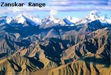
To the north of the main
Himalayas lies the Zanskar range. Its highest area is in the south eastern end with Leo Pargial rising just north of the
Sutlej, Shilla, and Shipki.
Several routes criss cross through this range. Some among them are Parang La, Lachalung La and Marang La, Nera La, and Kungri La.
Breaching the Zanskar range is the Zanskar River that flows north and creates a narrow opening between hills until it reaches the Indus River just below Leh. The range runs through Lahaul and Spiti District, acting as a buffer zone between the Himalayas and the Tibetan Plateau. It continues across Uttarkhand and again forms another zone between the Himalayas and the Tibetan plateau.
Kamet, the second highest peak in the Garhwal region, is also situated here.
The range ends near northeast of the river Kali, that is close to the Indo-Nepal border.