Nizamabad District lies on the north-western side of
Andhra Pradesh. It was earlier known as Indhrapuri or Indhur, and was formed in the year 1905. This region was under the rule of the
Chalukyas, Tugluk Dynasty, and Nizam Kings.
Nizamabad covers an area of 7,956 sq km with a population of approximately 2.3 million. It is situated at a considerable distance from the sea coast. The climate is tropical and temperature varies widely in the district. The normal rainfall is 1000 mm, of which about 85 percent comes from the south-west monsoon during the latter part of June to the end of October. Forests cover an area of 170,000 hectares.
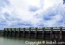
Important agricultural crops include paddy, maize, groundnut, red and green grams, sugarcane, and chilly. Nizamabad is irrigated by the Nizamsagar hydroelectric project.
Bodhan Sugar Factory is a major industrial establishment. Confectioneries and alcohol units are also found.
The important tourist destinations include
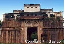
Nizamsagar, Pocharam Wildlife Sanctuary, Pochampad, Alisagar, Domakonda Fort, and Quilla Ramalayam apart from places of religious prominence such as Dichpalli Temple, Neelakanteswara Temple and Sarangapuram Temple.